Everything You Should Know About Mumbai Metro Line 2A
The yellow-colored Mumbai Metro Line 2A is an essential rapid transport system. By linking the city’s central, western, & northern suburban areas, it enhances urban mobility. The yellow line, which is projected to carry over six lakh riders per day by 2031, represents the beating heart of Mumbai. Continue reading to find more about the Mumbai metro line 2A’s route map, cost, schedule, and current state.
Are you searching 3bhk flat for rent in kharghar?
Mumbai metro line 2A, led by the Mumbai Metropolitan Region Development Authority (MMRDA), provides passengers with a dependable and effective mode of transportation. This line has drastically cut the commuting time between Andheri & Dahisar by forty minutes since it opened in April 2022. This blog provides important information and the most recent updates about metro line 2A.
An overview of Mumbai Metro Line 2A
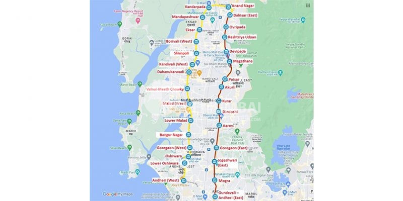
There are 17 metro stations along the 18-kilometer Metro Line 2A, which runs from Dahisar-Andheri West. One of the busiest roads in western Mumbai, New Link Road, is less congested thanks to this line. In addition, the MMRDA has renamed 15 of the 17 metro stations in response to public requests for station names that correspond to specific locations. Bangur Nagar, Shimpoli, and Valnai-Meeth Chowky are the new station names.
Here’s a quick overview of Mumbai metro line 2A’s stations:
| Mumbai Metro Line 2A Station List | |
| Mandapeshwar-IC Colony | Lower Malad |
| Borivali West | Goregaon Metro |
| Dahisar | Dhanukarwadi |
| Kandivali West | Lower Oshiwara |
| Eksar | Bangur Nagar |
| Anand Nagar | Valnai-Meeth Chowki |
| Shimpoli | Oshiwara |
| Kandarpada | Malad (West) |
| Andheri West | |
On April 2, 2022, the first phase of the Metro Yellow Line 2A was put into service. It runs from Dahisar (East) to Dahanukarwadi and contains nine stations. In the meantime, the second phase started operating in January 2023 and spans eight stations from Valnai to Andheri (West).
Mumbai Metro Line 2A: Schedule and fares
The metro line 2A fare and schedule chart is as follows:
| Aspect | Features |
| Line name | Yellow line |
| Length | 18.6 km |
| Number of stations | 17 |
| Type (Underground or elevated) | Elevated along Link Road |
| Interchange stations | DN Nagar (Ghatkopar-Versova on Line 1) |
| Shastri Nagar (Swami Samarth Nagar-Vikhroli on Line 6) | |
| Dahisar (Andheri East-Dahisar East corridor on Line 7) | |
| Timing | Start time: 5:55 am |
| End time: 10:30 pm | |
| Fare | Minimum fare till 3 km (Rs 10) |
| Maximum fare (Rs 50) |
Map of the Mumbai Metro Line 2A
Below is a map of Mumbai Metro Line 2A’s route:
Mumbai Metro Line 2A: The current status
Metro Line 2A is operating at full capacity at the moment. By 2031, 6.09 lakh commuters are anticipated to use metro line 2A each day, according to the MMRDA. The autonomous trains with real-time PIS on the yellow metro line, among other cutting-edge technologies, offer seamless connectivity and help to relieve traffic in the city.
Mumbai Metro Line 2A: Impact on Real Estate
Unquestionably, Metro Line 2A has revitalised the local real estate market. Property prices in areas such as Dahisar East have soared by 33 per cent in the previous three years due to an increase in housing demand. In a same vein, Borivali West has seen a marked increase in building projects and has become a magnet for commercial businesses and homes.
Conclusion, by improving connectivity throughout the city, Mumbai’s Metro Line 2A provides a workable transit option. In addition, the Yellow Line aims to lessen traffic while enhancing millions of inhabitants’ quality of life as it develops.
You’re looking for Projects in Bandra have the Best Properties In Mumbai Like Ready to Move:https://navimumbaihouses.com/properties/search/bandra/
If you want daily property update details please follow us on Facebook Page / YouTube Channel / Twitter


